
|
CLOSE WINDOW |
 |
Detail: 1936 MapFaulkner Mapping|Mapping Faulkner |
|
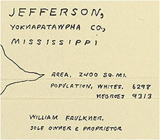
Faulkner himself drew at least two different maps of Yoknapatawpha. According to Joseph Blotner's biography, as Faulkner was finishing Absalom, Absalom! in the spring of 1936, Hal Smith, his editor at Random House, became increasingly concerned about the novel's readability. To address that issue, it was decided that the novel should include three appendices to "to clear up ambiguities and provide guideposts" for readers (937): a "Chronology" of events, a "Genealogy" of the major characters, and a map. It is not known who originated this idea, but its result was to make Faulkner a cartographer. Faulkner himself clearly chose what went on the map, since it barely addresses Smith's concerns. Absalom's Chronology and Genealogy focus entirely on events and characters in Absalom, but on the map Faulkner drew, only 5 of the 27 different locations identify places that occur in the novel; the other 22 refer to places that figure in his five earlier Yoknapatawpha novels. The map appears in the first edition of Absalom as a two-color foldout at the very end of the book. When readers unfolded the map (below), their attention was being directed well beyond this one novel, to the larger world that Faulkner had been building for almost a decade:   A decade later Faulkner drew another map, for a different book. In 1945, Malcolm Cowley put together The Portable Faulkner for Viking Press – a collection of stories and excerpts, organized chronologically. Although they had never met, the author and the editor worked closely together on the volume through the mail, and in a 10 November 1945 letter Cowley reminded Faulkner about "the map of Yoknapatawpha County" that had been printed for Absalom, asking about using it in the new book and adding "or you might even want to draw a new one." That's what Faulkner did. This time he based his decisions about what to plot on the map on the Portable's table of contents, which explains how "the convict" from "Old Man" – one of the two narratives combined in The Wild Palms (1939), and in which Yoknapatawpha is never mentioned – came to be born in the county. Below left is Faulkner's unfinished draft of this map. Below right: Faulkner's finished version, in two colors like his 1936 map:   Yoknapatawpha is much the same in both maps, bounded north and south by winding rivers, bisected vertically by the railroad, with its county seat just north of its geographical center. But although Faulkner does not include the "PINE HILLS" on the Portable map, its representation of the county's major roads, as they radiate like spokes from Jefferson in every direction but southwest, is much less stylized; those roads look like they were drawn with a ruler in 1936, but in 1945 they wind more realistically, as if around the absent hills. (On the other hand, the bends he added to the railroad tracks in the second map would probably result in a derailment.) The change in the map's northeast corner may be the most thematically significant difference. By 1945 he'd written the Go Down, Moses narratives about descendants of Lucius Quintus Carothers McCaslin; in some details "Old Carothers" closely resembles Virginius MacCallum, partriach of the MacCallum|McCallum family introduced in Flags in the Dust, the first Yoknapatawpha fiction, although as representatives of the values of the "old South" the two men and their legacies are strikingly different. Faulkner's decision to locate the McCaslin place on the map he drew for Cowley almost exactly on the spot originally occupied by the MacCallum place may be his way of calling attention to the way his representation of the southern past has evolved. Random House had Faulkner's 1936 map redrawn by a professional cartographer when it published Absalom in the Modern Library in 1951 (below left); the current Vintage International edition uses Faulkner's map, printed on facing pages instead of as a fold-out. These two maps are essentially the same, although Gabriele Gutting notes that the unknown cartographer added an unauthorized dot to the map on the southwestern corner of the Square, and the captions lack the idiosyncratic charm of Faulkner's handwriting. Viking decided not to use Faulkner's own map for the Portable. They printed a small map inside the front cover (below right), but it was drawn by a professional cartographer; this seems to have been Cowley's idea, as he feared that Faulkner's "lettering" was "not very legible." Cowley's collection is still in print, and continues to use this version. It's not known who added the legend to the bottom of this map, but if "Surveyed and Mapped for This Volume by William Faulkner" was William Faulkner's own phrase, then the difference between that and his 1936 assertion – "William Faulkner, Sole Owner and Proprietor" – may be worth more critical attention than anyone has given it.   Our Digital Yoknapatawpha project to visualize the Yoknapatawpha fictions would be much harder without the two maps that Faulkner himself drew. They provide the cartographical starting point for all our maps of the county, and whenever possible we defer to his authority to establish the features of Yoknapatawpha and the locations that appear in the fictions. The link below will take you to an interactive exhibit where you can compare Faulkner's two maps with each other, and either of those maps with the project's version of the place.  There is, however, a crucial conceptual difference in what his and our maps re-present. Both of his maps display multiple texts. Faulkner's main ambition in the 1945 map is clearly to find a place inside Yoknapatawpha for all the selections in the Portable Faulkner, no matter how imperfect the fit. The 1936 map may have also had a rhetorical motivation, as a visual way for him to advertise his earlier novels – or at least, like Cowley's design with the Portable, to call attention to his work's recurring imaginative engagement with a single place. The few critics who have discussed the 1936 map have rightly emphasized how much its significance depends on its aggregate nature. Robert Hamblin, for example, argues that Faulkner chose to include locales and events from those earlier novels in order to "reiterate and extend the tragic view of life and history" depicted in Absalom: on the map that ends the book, "the landscape of Yoknapatawpha is presented primarily as a setting for grief, villainy, and death." To Elizabeth Duvert, the cumulative intertextual sweep of that map can be read as "Faulkner's vision of landscape as spatialized time." Each of the project's maps, however, represents a single novel or short story. Where possible, we rely on Faulkner's maps, but there are quite a few places where that is not possible. The Armstid place, for example. Faulkner includes it on the 1936 map (above), locating it southeast of Jefferson and northeast of Frenchman's Bend, along a road that comes into Yoknapatawpha from still further east. This is where Armstids' Farm appears in Light in August (1932): the road is the one on which Lena Grove is walking after leaving Alabama, Armstids' is the place where she spends her first night in the county, and our map of that novel locates the road and the place where Faulkner does (below left). But the Armstids' farm is also a location in As I Lay Dying (1930), where it is south of Frenchman's Bend – on the river that the Bundrens have to cross on their journey to Jefferson. On the maps that capture his sense of Yoknapatawpha at two specific moments in his career, Faulkner had to pick one place for each location. Nor does Faulkner ever seem to have been very troubled by the way certain parts of his county move around between texts. But when that happens, we follow the text rather than his maps to establish locations on the maps. Each location entry notes the "Authority" for its placement: in Light in August the "Authority" for Armstids' is "Faulkner map"; in As I Lay Dying it is "Context (text as interpreted)." (Searching Digital Yoknapatawpha's Locations for "Armstids'" reveals them both, as well as the other four texts in which the location appears.)   Even the largest elements on the maps are not consistently plotted. Take the two rivers that form the county's northern and southern boundaries on both Faulkner's maps and in many of his texts – just as the Tallahatchie and Yacona Rivers help define the borders of Lafayette County, the real place on which so much of Yoknapatawpha is based. The narrative of Flags in the Dust (1929) follows young Bayard Sartoris as he drives to a college town just beyond "the hills" to the north. He clearly leaves "Yocona," as Faulkner calls his mythical county in this novel, but just as clearly never crosses a river while traveling through the hills. Later, however, while hunting with Buddy MacCallum 14 or so miles northeast of Jefferson, Bayard stalks ducks and geese "along the river channel." So in our representation of the natural features in this novel, the Tallahatchie puts in a brief appearance in the northeast corner of the map, then vanishes to the north (below left). In As I Lay Dying, the southern river behaves even more strangely. In order to provide the Bundrens with the "flood" that Faulkner listed along with "fire" as the ordeals the family had to surmount, while still making it possible for them to reach Mottson without re-crossing it, the river on the novel's map has to make a sharp left turn and disappear to the south (below right).   There are many other discrepancies between Faulkner's maps and ours. The biggest liberty we took was to put the town that Faulkner calls Mottstown in some texts and Mottson in others at the very bottom of the Yoknapatawpha map; by either name, this town is the seat of the county just south of Yoknapatawpha and should appear as a dot on the REGION inset map, but visually we wanted to keep the events that occur there on the main map. For more details about discrepancies and choices, see the Mapping the Story sections in many of the "About the Text" notes for individual works. There are also many places where in order to determine where to put something on the map we had to refer to other texts, or use our best scholarly judgment. "Other texts" and "Speculation" are other kinds of "Authority" we cite. Yet even when we had to speculate, Faulkner's maps provided us with a kind of reassurance. Yoknapatawpha is an imaginary place, and so no global positioning technology can help us find our way across its landscape or among its settings. But Faulkner's Yoknapatawpha doesn't just exist in his mind and his books. He also chose to map it, to give it existence visually. For him too it was important to organize his fictional world spatially and geographically. Despite the care with which we have made them, our maps should be understood as approximating his world. But by redrawing the map for every novel or short story, we are also trying to represent visually the creative ferment out of which he created and re-created that world each time he returned to it. As is well known, Faulkner's "mythical county" is his imaginative rendering of the real Mississippi county where he lived for most of his life. Lafayette was one of ten counties created by Mississippi in 1836, just after the Chickasaw Indians formally ceded their domain in the northern part of the state and moved away. Originally Lafayette was a square with what Don H. Doyle describes as "a stubby panhandle attached to its southeastern corner"; later changes removed the panhandle, altered the northeastern boundary to follow the Tallahatchie River, and took a bite out of the county's southwest, but Lafayette remains essentially a square with 27-mile-long sides (below left). When almost exactly one hundred years later Faulkner sat down to draw his first map of Yoknapatawpha, it's clear that he started with a piece of paper shaped like the blank pages on which he'd been creating his county in words since the late 1920s: Yoknapatawpha is a rectangle taller than it is wide (below right). Drawing it Faulkner straightened the Tallahatchie and Yocona Rivers, turning them into top and bottom margins. There's no way to know how deliberately he re-drew the shape of his county to align it with the shape of his writing paper, but the result is a symbolically apt blending of the real and the textual, somewhere between the landscape of Mississippi and realm of Faulkner's art: |
  |
|
It's easy to see how closely Yoknapatawpha resembles Lafayette. The two county seats – Oxford and Jefferson – sit near the center, beside the railroads that bisect each county vertically and in the middle of the major roads that lead from town in every direction except southwest. On his map Faulkner claims that his county contains 2400 square miles, which would make it four times larger than Lafayette, but that claim is belied by the distances he repeatedly provides in his fictions, where Sutpen's Hundred is 12 miles northwest of Jefferson, the MacCallum/McCaslin properties 14-15 miles northeast, and Frenchman's Bend 12-20 miles southeast. Using these figures, Yoknapatawpha is nearly the same size as Lafayette (i.e. 679 square miles). In both counties, the richest farm land and most of the large cotton plantations are north of town, while the hill country to the east and south is poorer and, in part as a result of the absence of plantations, whiter. According to Faulkner's map, 15,611 people live in Yoknapatawpha in 1936, which is slightly fewer than Lafayette's 19,978 (1930 census) or 21,257 (1940 census). But Faulkner flips the racial proportions: his county is 60% black, while in the 1930s Lafayette was 60% white. The other major respect in which Yoknapatawpha is different from Lafayette is that Faulkner leaves out the University of Mississippi, which in reality has been on the western edge of Oxford since the 1840s. One of the great challenges we face in trying to represent Faulkner's world digitally is his love of polyphony, ambiguity and indeterminacy. For example, "Race" is a field in our Character database, where it is divided into ten different categories. But none of them seem adequate to the way Faulkner uses Joe Christmas to enact race as both an existential challenge and an ideological performance. What race does Christmas belong to? Faulkner's narratives are repeatedly organized around such unanswerable questions. Who is Caddy Compson – the sister Benjy loves or the one Jason hates? Who was Thomas Sutpen, and what is the past he epitomizes, the past which may never be dead but which remains elusive, perhaps unknowable? Faulkner is one of the modern writers who transformed the novel in order to represent what Henry Adams, looking for fixed truths, ruefully summed up as "twentieth century multiplicity." Pamela Dalziel locates Faulkner's 1936 map in the context of this project. In her reading, the map's creator is yet another of Absalom's story-tellers, whose visual representation of Sutpen adds yet another interpretive layer to the accounts of Rosa or Mr. Compson or Quentin and Shreve, requiring the reader to entertain yet another way of "looking at a blackbird." The discrepancies between Faulkner's maps and his texts, or between the two maps themselves, could be similarly viewed. But throughout Faulkner's work the reality of chaos and indeterminacy (or the chaos of reality) competes with the need, perhaps as much psychic as artistic, for order and precision, for putting each thing (to quote the last four words of The Sound and the Fury) "in its ordered place." Light in August brilliantly juxtaposes Joe Christmas' and his southern culture's rage for racial certainty against the narrative's refusal to define his "true" identity, yet when McEachern attends church in Chapter VII of the novel, Faulkner measures the exact distance he travels – three different times. In the manuscript the distance is "8 miles," but when he typed the book he recalibrated it as "five miles," before changing it again in a hand-written revision to "three." Since the reader stays home with Joe and Mrs. McEachern, this fussiness seems over-determined. Faulkner's manuscripts and texts contain many such recalibrations and specific details. Like all forms of art, maps provide a way to impose order on the world, to step outside the welter of experience and apprehend it, to look at life – like an airplane pilot, which Faulkner also was – from a higher and wider perspective. Four other Faulkner maps in the collections at Southeast Missouri State and Virginia show his quest for order in the context of his own life. Below left: The river at the bottom of this schematic map is the Thames rather than the Yoknapatawpha. Twice during the years after he won the Nobel Prize, Faulkner stayed at Brown's Hotel in London's Mayfair district, first in 1950 on his journey home from Stockholm, and again in 1952, on his way to Paris. The folds in the paper suggest Faulkner may have carried this with him on one of these trips, to make sure he could find his way to the hotel – just as the numbers at the top of the page helped him navigate the unfamiliar British currency. Below right: Several times in the early 1950s Faulkner visited Princeton, New Jersey, as the guest of Saxe Commins, his editor at Random House; on these trips he stayed at both Commins' house and at The Princeton Inn. The few details on this map – "Library Place" and "O [or C?] CiR.," which may be Cambelton Circle – make it likely that it shows the route between the Princeton University train stop (bottom of page) and the Commins' house on Elm Street (top of page). Faulkner may have drawn it for Joan Williams, with whom he was having an affair and who is known to have visited him in Princeton in 1952, though the paucity of labels may mean Faulkner drew it for himself. In either case, like the London map, it was intended to guard against getting lost in an unfamiliar world.   In the Faulkner Foundation collection guide, the two Faulkner maps below are identified as "maps of Lafayette County, intended as frontispiece" for the 1939 novel The Wild Palms; as Thomas McHaney was the first to point out, however, they are two slightly different versions "of a small section of the Mississippi Delta" in Sharkey and Yazoo counties. This is where, during the 1940s and 50s, Faulkner regularly went on the kind of hunting trip he describes in both "Delta Autumn" and "Race at Morning." Gabriele Gutting points out how closely Faulkner's maps follow the Mississippi state map of the Sunflower Wildlife Management Area, including the way Faulkner divides the region into those township quadrangles and uses cross-hatching to identify the areas that are privately owned, and so off-limits to hunters. The red dots, including the ones near the center of both maps labeled "Oxford" (which presumably explains how the maps were misidentified), locate the camps of the different hunting parties that are scattered around the woods. The odds are that Faulkner drew these meticulously organized maps – note how he corrects some grid numbers on the righthand map – to equip himself and his companions in the "Oxford" camp with a guide that could prevent against accidentally walking in front of another hunting group's guns. In Princeton or London one could get lost; in the wilderness during hunting season getting lost could mean getting mistaken for game and shot!   On a hunting trip in "The Bear," in Yoknapatawpha's Big Woods, Ike McCaslin discovers the scriptural truth that one has to get lost in order to find oneself, but that's an exceptional moment in Faulkner's fiction. More representative is what happens at end of The Sound and the Fury, when Luster fails to follow the correct route to the cemetery, and Benjy Compson is plunged into horrifying chaos. Faulkner's Civil War novel, The Unvanquished, begins with a wonderful scene in which two southern boys, one white and one black, create a "living map" of the battle for Vicksburg in the earth of the Sartoris place. At the historical moment when the Confederacy is about to lose its last stronghold on the Mississippi River, and so make inexorable the ultimate loss of the southern world that Ringo and Bayard have always known, the boys try to create "a shield between ourselves and reality, between us and fact and doom." Map-making turns out to be a form of resistance, against getting – or being – "lost." Citing this source: SOURCES: Joseph Blotner, Faulkner: A Biography, 2 volumes (Random House, 1974); Malcolm Cowley, The Faulkner-Cowley File: Letters and Memories, 1944-1962 (Viking Press, 1966); Gabriele Gutting, Yoknapatawpha: The Function of Geographical and Historical Facts in William Faulkner's Fictional Picture of the Deep South (Peter Lang, 1992); Robert W. Hamblin, "'Longer than Anything': Faulkner's 'Grand Design' in Absalom, Absalom!," in Faulkner and the Artist, edited by Donald M. Kartiganer and Ann J. Abadie (University Press of Mississippi, 1966, pp. 369-93); Elizabeth Duvert, "Faulkner's Map of Time," The Faulkner Journal, Fall 1986, pp. 14-28; Don H. Doyle, Faulkner's County: The Historical Roots of Yoknapatawpha (University of North Carolina Press, 2001); Pamela Dalziel, "Absalom, Absalom!: The Extension of Dialogic Form," Mississippi Quarterly (Summer 1992), pp. 277-94; Thomas McHaney, Introduction to The Wild Palms: Publisher's Front Matter and Typescript Setting Copy (Garland, 1986), p. 393; Gabriele Gutting, "The Mysteries of the Map-Maker: Faulkner, If I Forget Thee, Jerusalem, and the Secret of a Map," Faulkner Journal (Spring 1993), pp. 85-89; |